Volcanoes in Southwest Utah
When you think, “Volcano” – southwest Utah is probably not the first location that comes to mind. But there was a time when Southwest Utah was a landscape like Hawaii or Iceland.
Sunset Crater in Northern Arizona has been elevated to a National Monument. They make a big deal about it because it happened only a thousand years ago when native Americans were living there. Hmmmmff! “Just north of [Zion] park in the Markagunt volcanic field near Cedar Breaks and Panguitch Lake, there was an eruption only 1,000 years ago.” (https://www.nps.gov/zion/learn/nature/volcanoes-of-zion-and-southwest-utah.htm) Southwest Utah has cinder cones scattered here and there all across the region. The small city of Hurricane is sandwiched between two of them.

And it’s not just something that we can just brush off because it happened in the long-ago past – because it didn’t. According to the National Park Service, “Zion is in an active volcanic field called the Santa Clara. Eruptions in this field are typically on the order of one every few 10,000 years.” In 1992, the St. George area was rocked by a magnitude 5.8 earthquake in the Hurricane Fault that triggered a landslide. A whole subdivision in Springdale was destroyed. According to the National Park Service, “Twelve times over the last 1.5 million years, basaltic lava flows have flowed over the landscape and down the Virgin River or its tributaries.” (For perspective, the meteor that killed the dinosaurs landed a little over 66 million years ago. Utah red horn coral is over 300 million years old.)

Probably the biggest geological feature is called Pine Valley Mountain today. Guinness has not certified it, but it is probably the biggest “laccolith” in the world. It’s a biggie. Wikipedia calls it the biggest in the U.S. One of the larger “Wilderness Areas” in Utah is there. My picture only shows the south end. It extends almost up to Cedar City.

Pine Valley Mountain does have competition for the “biggest” prize. According to the National Park Service, the Navajo Sandstone is, “a remnant of the largest sand dune desert known to have ever existed on the planet containing 14,000 to 34,000 cubic miles of sand.” Texas beware! We got ‘em big in Utah too! The biggest single organism in the world (measured by mass) is Pando the Aspen Tree in the middle of the state.
So what’s a laccolith? (I hear you asking.) So glad you asked. Here’s how Wikipedia describes it.
A laccolith is a body of intrusive rock with a dome-shaped upper surface and a level base, fed by a conduit from below. A laccolith forms when magma (molten rock) rising through the Earth's crust begins to spread out horizontally, prying apart the host rock strata. The pressure of the magma is high enough that the overlying strata are forced upward, giving the laccolith its dome-like form.
Here at KinesavaROCKS, Salina Canyon Wonderstone (Available at my store!) started out as a laccolith. But the Salina wonderstone laccolith is only a few inches thick.

Why does Pine Valley Mountain look like just another mountain? (Another good question. Keep ‘em coming!) Because all the host rock on top has eroded away and only the harder volcanic rock is left now. This volcanic feature is around 20 million years old. (That’s still only a third as old as the dino killing meteor strike! Read my blog, Deep Time.)
Magma, the stuff that created Pine Valley Mountain, is the duct tape of geology. So many interesting things are made of it -- from rocks that float (pumice) to inverted topography.
I hear you asking, “What’s inverted topography?” It’s going to take more than a quote from Wikipedia to explain it.

The Earth has always had river valleys and occasionally, rivers of hot molten lava. When that happens, as it has at least 12 times in southwest Utah, you get a “frozen” river of rock where a real river used to be. Time passes. (Did you read Deep Time like I told you to do?)
As we have seen in Pine Valley Mountain, it’s natural for whole formations of geology to simply erode away. But. since the basalt rock that the magma became flowed down the river valleys, the mountains that used to be there eroded away much faster than the hard basalt. The high became low and the low became high. (Isn’t there a Bible verse like that?)
Here’s a sequence produced by the National Park Service that shows that happening.
These “inverted" rivers of magma can be found throughout the world, but some of the best examples are in southwest Utah.
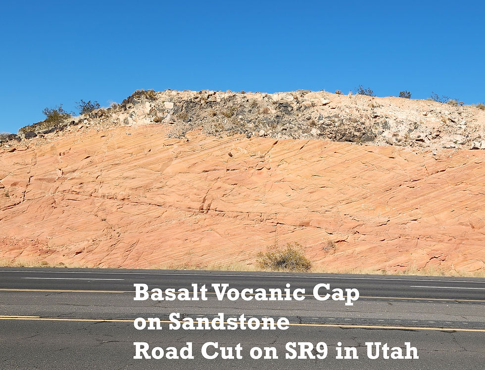
Here’s a road cut showing our famous Navajo Sandstone buried beneath a cap of lava.

Here’s a beautiful example that towers above the road leading up to Zion Canyon. The Zion Canyon “West Temple” can be seen in the background.

With the wisdom and foresight they’re famous for, the pioneers who built St. George, Utah put their airport right on top of a high mesa. Both ends of the runway drop straight down off the side.
I was actually on jet airplanes that used good old Kamikaze Airport. Today, the airport has been moved out into the desert right on the Arizona border. Dixie Technical College is up there on top now.

It’s handy because students don’t have far to go to jump over the edge when they fail their calculus final exam.
Comments